Gobi Desert Dust Storms Seen From Space
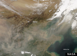
Several natural-color photos taken by theModerate Resolution Imaging Spectroradiometer (MODIS) on the Aqua satellite show the giant dust clouds as they "fanned out toward the southeast" from the Mongolian border towards Beijing.
By April 27, "a veil of dust hung over eastern China, with a fairly thick plume stretching across Bo Hai," according to Earth Observatory.
Scroll Down For Images Of Gobi Desert Dust Storms From Space
The Gobi Desert, which sits on the border between China and Mongolia, frequently produces dust storms during the spring, which generally peak in April, according to a climatology study of Mongolia published by Elsevier. The study goes on to show that most of southern Mongolia sees dust storms on an average of 20 to 30 days a year.
The website for the International Fund for Agricultural Development (IFAD) lists the Gobi Desert as one of several regions in the world where desertification -- the degradation of land to desert -- is occurring, and points to the effects of desertification on air quality in Beijing.
A 2009 story published in The New York Times illustrated a method of dune stabilization employed by the United States Geological Survey scientists to help counteract desertification in arid regions, but suggests that the larger culprits that must be addressed are climate change and water shortages.
Comments
Post a Comment